I wanted to reach out to you as 2020 comes to an end. A combination of natural and man-made disasters hit our isolated hamlet of Haines, Alaska. Hard.
In addition to the pandemic, low fish runs and recent record-breaking rains have combined to stress our community to its limits. In Haines, the power of nature cannot be ignored. The dramatic mountains and scenery propelled many of us to move here to make Haines our home. They provide daily inspiration.
What happens when these mountains, which once inspired, bring a tinge of fear? On Wednesday, December 2nd, disaster peaked with a massive slide along Beach Road that carried several houses down to the water. Two well-loved local residents disappeared and have not been seen since. Beaches are strewn with a combination of construction materials, battered spruce trees and a few identifiable personal items. Almost half of those living within our townsite were given instructions to be ready to evacuate their homes at a moment’s notice.
Rescue workers and experts in various fields from all over the region descended on our community to help. Emergency shelters and temporary offices were set up. Gofundme campaigns sprouted and money poured in. Nightly briefings were aired on our community radio station, KHNS. As a naturalist, I was particularly fascinated by the comments made by one of the experts, Ronald Daanen. He’s a geo-hydrologist with the Alaska Department of Natural Resources. Ronald analyzed the Beach road slide. This is what I understand to be the cause of the slide after hearing his initial comments:
Glaciers are leading characters with so many dramas set in Southeast Alaska . Above the area where homes and lives were lost, different types of rock had been transported and deposited by glaciers during the last Ice Age. These rocks intersect and interact with each other and with the original bedrock. The original bedrock has been exposed and broken down over the eons. Intersections between different types of rock create areas where water can enter. Water infiltrating into rock increases pressure on the soil. This creates a weak point, a natural break, a starting point for a landslide. The weight and pressure on the super-saturated soil from the huge rains, the decreased friction due to the moist bedrock, and the angle of the slope combined to create a “perfect storm” of conditions for a landslide.
Many years ago, I invited my friend and fellow naturalist Greg Streveler to Haines to share some basic training in geology for our Rainbow Glacier Adventures guides. Greg described long-term, incremental forces like plate tectonics and glacial movement which have modified and created the basic shape of our landscape.
He also discussed other forces that visibly and sometimes catastrophically affect the Chilkat Valley today. Haines lies in a transition zone between the wet rainforests of the coast and the dry interior of Alaska and Canada. In dry areas, forest fires are the major factor shaping the landscape. Haines technically lies in a rainforest, so I was surprised when Greg pointed out signs of past forest fires along the slopes of Mt. Ripinski, clearly visible from town.
In Haines, landslides and avalanches are the driving forces behind catastrophic natural events. As Greg looked across the Lynn Canal and around the Chilkat Valley, he pointed out numerous locations that showed signs of recent and past avalanches and landslides.
Fires, avalanches and landslides. We do our best to control them. We have burn bans and fire fighting crews that spring into action when we are threatened. Traditional avalanche areas are easy to identify by the combination of slope angle and vegetation type and so are avoided as homesites. But areas prone to landslides are harder to detect and predict. With climate change and increasing development, landslide prediction becomes a higher priority.
In nature and in life, everything pulses. One level of intensity or relaxation cannot continue indefinitely. The record-breaking rainfall that fell and the high levels of trauma we experienced could not be sustained.
The break came with sunshine and plunging temperatures. River levels fell, wet ground coalesced, and the community came together to repair and heal. The alert level was dropped, many displaced residents were able to return to their homes and kids went back to school last week. We inch our way towards “normalcy” while heavy rains and snow return to our beloved Chilkat Valley.
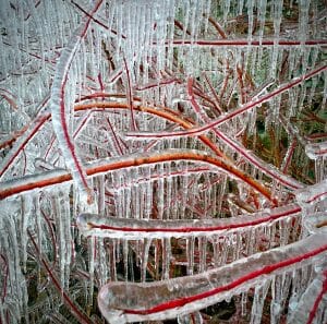
As a photographer and naturalist, I find solace in nature and pleasure in sharing my images with others. The image I share today is from the roadside near the Letnikof Cove Cannery. The rain and supersaturated ground resulted in copious drips of water along the face of the cliffs that line Mud Bay Road. As the temperature dropped, the steady drips of water froze in layers on the branches of the red-osier dogwood bushes below.
I share this photo with you with kind thoughts for you and your loved ones. If you want to help the residents of Haines, a good contact is the Haines Community Foundation Relief Fund. The link is https://chilkatvalleycf.org/
Best wishes for 2021 from the Ordóñez family and the team here at Rainbow Glacier Adventures.
Joe, Edie, Stella and Sapphire Ordóñez